Enhanced Fujita Scale: Difference between revisions
m (Rewrite with Template:Term and clean up) |
|||
| (4 intermediate revisions by the same user not shown) | |||
| Line 5: | Line 5: | ||
A six-level numerical, damage-based classification of estimated wind speeds. Following suspected high-wind events, affected areas are surveyed to provide an EF-scale rating. These high-wind events are typically [[tornado]]es. However, the EF scale has also been applied to [[downburst]]s and [[tropical cyclone]]s. | A six-level numerical, damage-based classification of estimated wind speeds. Following suspected high-wind events, affected areas are surveyed to provide an EF-scale rating. These high-wind events are typically [[tornado]]es. However, the EF scale has also been applied to [[downburst]]s and [[tropical cyclone]]s. | ||
Investigators determine an EF-scale rating using its primary methodology whereby wind speeds are estimated by assigning degrees of damage (DoD; DoDs range from first visible damage up to complete destruction, with higher specified wind speeds linked with increasing incremental amounts of observed damage) for various damage indicators (DI; there are 26 anthropogenic DIs, such as residences, strip malls, and motels, along with hardwood and softwood trees). For tornadoes, these maximum wind speed estimates are used to determine the operational EF-scale rating, as shown in Table 1. Traditionally, an EF-scale rating depends on damage to an established DI and may not be representative of true maximum wind speeds, especially in areas lacking DIs. | Investigators determine an EF-scale rating using its primary methodology whereby wind speeds are estimated by assigning degrees of damage (DoD; DoDs typically range from first visible damage up to complete destruction, with higher specified wind speeds linked with increasing incremental amounts of observed damage) for various damage indicators (DI; there are 26 anthropogenic DIs, such as residences, strip malls, and motels, along with hardwood and softwood trees). For tornadoes, these maximum wind speed estimates are used to determine the operational EF-scale rating, as shown in Table 1. Traditionally, an EF-scale rating depends on damage to an established DI and may not be representative of true maximum wind speeds, especially in areas lacking DIs. | ||
<blockquote>Table 1: EF-scale wind speed ranges as a function of rating. The wind speeds correspond to an estimated 3-s gust at 10 m AGL. Wind speed ranges are given in meters per second, with the equivalent ranges in miles per hour in parentheses.</blockquote> | <blockquote>Table 1: EF-scale wind speed ranges as a function of rating. The wind speeds correspond to an estimated 3-s gust at 10 m AGL. Wind speed ranges are given in meters per second, with the equivalent ranges in miles per hour in parentheses.</blockquote> | ||
[[File:EF_Table.png| | [[File:EF_Table.png|450px|center]] | ||
[[File:EF-definition-aerial-example.png|600px|center]] | [[File:EF-definition-aerial-example.png|600px|center]] | ||
| Line 25: | Line 25: | ||
''term added 8Oct2013'' | ''term added 8Oct2013'' | ||
Latest revision as of 06:56, 29 March 2024
Enhanced Fujita Scale[edit | edit source]
(Also known as the EF scale.)
A six-level numerical, damage-based classification of estimated wind speeds. Following suspected high-wind events, affected areas are surveyed to provide an EF-scale rating. These high-wind events are typically tornadoes. However, the EF scale has also been applied to downbursts and tropical cyclones.
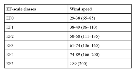
Investigators determine an EF-scale rating using its primary methodology whereby wind speeds are estimated by assigning degrees of damage (DoD; DoDs typically range from first visible damage up to complete destruction, with higher specified wind speeds linked with increasing incremental amounts of observed damage) for various damage indicators (DI; there are 26 anthropogenic DIs, such as residences, strip malls, and motels, along with hardwood and softwood trees). For tornadoes, these maximum wind speed estimates are used to determine the operational EF-scale rating, as shown in Table 1. Traditionally, an EF-scale rating depends on damage to an established DI and may not be representative of true maximum wind speeds, especially in areas lacking DIs.
Table 1: EF-scale wind speed ranges as a function of rating. The wind speeds correspond to an estimated 3-s gust at 10 m AGL. Wind speed ranges are given in meters per second, with the equivalent ranges in miles per hour in parentheses.
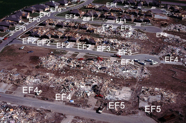
Gradations of damage ranging from EF0 (in upper-left corner) to EF5 (in lower-right corner). EF-scale ratings have been assigned to select one- and two-family houses.
Image courtesy of T. Marshall.
The correspondence of wind speed to damage was determined using linear regression of the data points relating wind speeds, the Fujita scale (F scale) categories, and damage obtained via an “expert elicitation” process. The EF scale was created to improve the wind speed–to-damage relationship, increase the number of DIs (28), maintain continuity with tornadoes rated with the F scale, and allow future modifications. In 2007, the U.S. National Weather Service adopted the EF scale, supplanting the F scale. Other countries (e.g., Canada and France) have also adopted the EF scale, but with minor modifications.
Reference:
Edwards, R., J. G. LaDue, J. T. Ferree, K. Scharfenberg, C. Maier, and W. L. Coulbourne, 2013: Tornado intensity estimation: Past, present, and future. Bull. Amer. Meteor. Soc., 94, 641–653.
term added 8Oct2013


